
Yesterday was one of those perfect days when you are surprised with a great adventure. We had planned on going to the FMCA show in Indio but at the last minute found out that not all the exhibits would be open on day one. We decided we would drive up to Idyllwild for some cold mountain hiking. We packed coats, hats, gloves and our microspikes and headed west on the I-10. We did not go far when we noticed the entire San Jacinto mountain area was encased with clouds. It was obviously raining/snowing in the area and we needed to come up with a new plan. I had been studying the Delorme map earlier in the day and noticed an “interesting geologic feature” called Amboy Crater. We plugged it into GPS and we were on our way. We were treated to some of the best horizon to horizon rainbows we have ever seen as we exited the I-10 and headed on Rte 62 up the Morongo Valley. 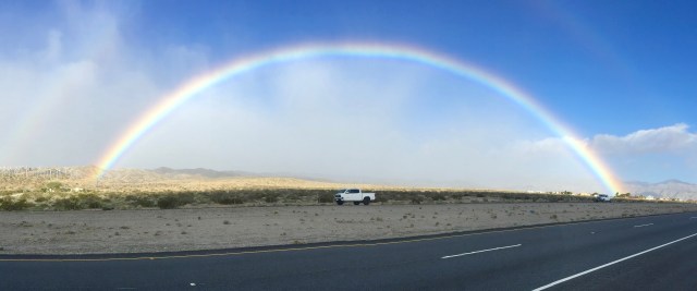
The drive was an easy one, we traveled on Rte 62 until we turned on to the Amboy Road. We continued on this until just before the crater when we turned on to Route 66. The drive was about 110 miles and took just over 2-hours from Palm Desert.
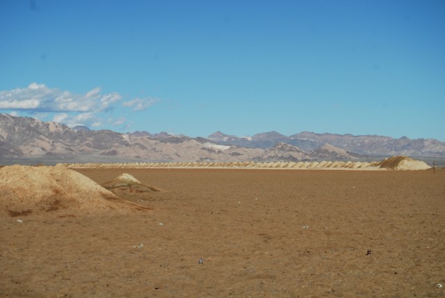
We had great views of Amboy Crater as we drove on Rte 62 towards the town of Amboy.  Just before the end of Rte 62 we came to the Bristol Dry Lake. It is a dry lake that is 14 miles long by 12 miles wide. This lake has been actively mined since 1909. The area has 60 million tons of salt in reserve. The surface layer, which is three to seven feet thick, is removed to get to the salt. This layer is then dumped in cone shaped piles along trenches. We initially thought we were looking at a very unique geological feature and then after “googling it” we found out the cone shaped piles were man made. They were still cool to look at.
Once you get to the junction with Route 66 you turn left and drive about 1 mile to the road to Amboy Crater. The Amboy Crater is designated as a National Natural Landmark. 
This crater is in one of the youngest volcanic fields in the United States. The crater was designated as a National Natural Landmark in 1975 due to its near-perfect shape and its recent origin.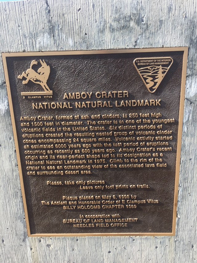
The drive into the crater is on a paved road and there is plenty of parking at the trailhead. There is a well maintained picnic area with several covered picnic tables as well as vault toilets.
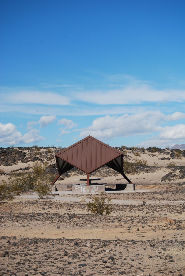
There were several covered picnic tables at the trailhead
The hike out to the crater is a relatively flat 1.1 miles through sand and volcanic rocks. 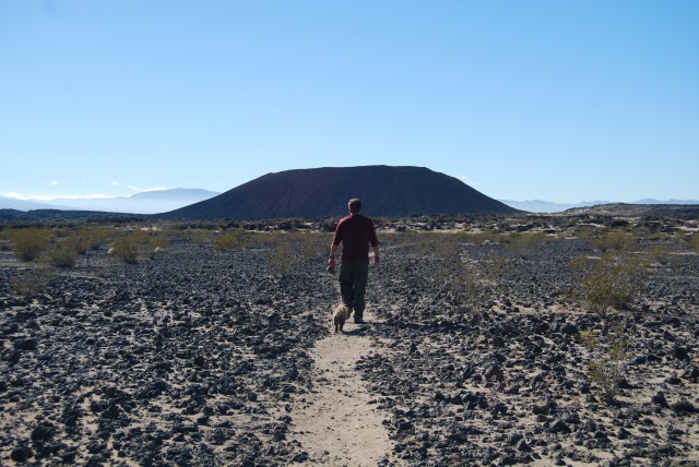
There are rest areas with benches and shade cover at the .5 mile and 1 mile mark. We were warm and the temperatures were in the low 60’s. I can’t imagine hiking this during the summer months.

1 mile mark with rest area
The trail brings you around to the back of the crater where there is a breech in the wall. This allows you to hike up into the center of the crater. Can I just say, this is one of the coolest things I have done!

This is Gizmo hiking down from the rim. You can see where we entered the crater. We couldn’t continue straight ahead as it was too wet. You can’t tell from the picture but the trail Gizmo is on is VERY steep.
Once inside the crater make your way up one of the various paths to the top. You can walk around the circumference of the rim and then make your way down another path. The views from the top are amazing.

You can see someone has a great sense of humor and made a smiley face
John and I both agree this is one of the best “short hikes” we have done on this trip.
We decided to take a few minutes after the hike and drive about 5 miles east on Route 66. We were trying to get a look at a “shoe tree” and Roy’s Motel and Cafe. 
We didn’t find the shoe tree, but as we were traveling east on Route 66 we saw 2 large Chinese Guardian Lion statues just off the side of the road. Of course we had to get out of the car and hike out to these to see what they were.
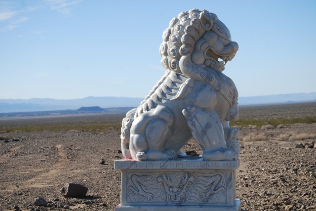
Just off the road- great views of Amboy Crater in background
There was a journal for visitors to sign, but no information about the statues. We googled this too, to find out more information. The lions are about 6-7 feet tall and are about 1/4 mile apart. They secretly appeared in this location around 2013 but little else is known about them.

Pingback: The End of the Journey West and the Beginning of the Journey East | gizmogoeswest