
We had an chilly start to the day with a thick coat of frost on the car. This led us to take our time getting ready to head out for the day. Once the sun came out the temperature jumped up quickly and it was too hot to do a hike without shade. We decided that our adventure for the day would be to try to find the southern terminus of the Pacific Crest Trail(PCT). I had read online that it can be tricky to find and there would be a walk of about 1/2 mile to where the start is. The weather was forecast to be around 70 for the day but the Santa Ana Winds were still with us. It was pretty calm at our campsite but the strongest winds were being recorded in Campo, our destination. We figured we would take our chances as the winds were supposed to die down as the day progressed. We programmed Campo into our GPS and it would be about a 45-50 minute ride. We were not sure of the exact location but we had our Delorme California map with us and we were pretty sure we would be able to find it. We left Pio Pico and turned right on to Campo Road (Rte 94) and followed it all the way to Campo. This is a very scenic and winding drive that is surrounded by mountain peaks that are around 4000 feet tall.

Beautiful winding drive on Campo Road
One of the most prominent peaks along the route is Tecate Peak, just under 4000 feet.

Tecate Peak- You can see the dirt road going up if you look close
There is a trail (dirt path) that is around 12 miles round trip that leads to the summit. You can see on the map that the trail pushes right up against the border with Mexico in several places, but the entire trail is in the United States. The border crossing to Tecate, Mexico is along this route, you just turn down route 188. I read online that it is a 10-minute walk to the Tecate brewery where you can take a tour and get a beer.
Our GPS brought us to Cameron Corners which is actually pass where you want to turn to get to the monument at the start of the PCT. There is a large convenience store here with a wide selection of food as well as a Subway. We decided to drive past this location and take the first right and travel south towards what we thought would be the monument. We traveled down this for a few miles and made several wrong turns trying to find our way. We did eventually end up on the right route and made it to the start of the PCT.
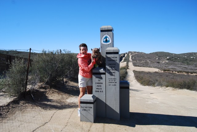
Wind was howling. Gusts up to 50 MPH. This is a brand new monument- it was replaced a year ago
The final section of the drive is on a rough hard packed dirt road, passable by most vehicles. You just need to take your time and watch out for washouts. We parked the car in a large opening next to a plaque on the ground. There is a fir tree right next to the plaque. You will see the border wall directly in front of you. Look to your left and you will see the top of the monument sticking up. You will need to walk the remainder of the distance, about 0.1 miles up a steep hill on a dirt path.

John and Gizmo heading back to the car from the monument
The monument is literally right at the border with Mexico and you can watch the border patrol driving back and forth.

The monument sits right on the border with Mexico
The wind had not died down in this area and we were getting gusts upwards of 50 MPH, and sand was blowing. We posed for some quick photos and rushed back down the hill. Our next objective was to find the best way to the monument, since that is not what we had done.
So, here it is. Once you arrive in Campo you will be looking for a green store on your left. It is called the Campo Store.

Definitely worth a stop here
You will turn right here on to Forrest Gate Road.  You will see additional signage along the way indicating the direction to the start of the trail (it is basically straight.)
  The distance from the store to the start of the trail is between 1-2 miles.
Make sure to stop at the Green Campo Store before you leave town. They have a large selection of reasonably priced craft beer. There is a historic marker and museum for the Campo Stone Store, located behind this store. 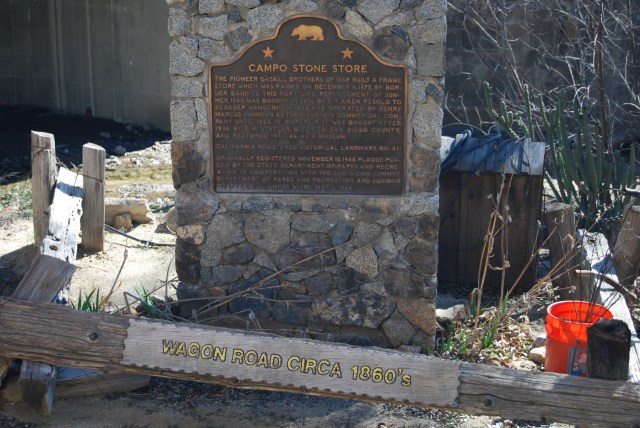 This original store was built in 1868 and was relied upon by people from both sides of the order. The store was also the bank and post office. In 1875 the store was raided by border bandits. It was rebuilt out of stone in 1885 and designed to be much more secure. Camp Locket, a military outpost was located in this area too. It was home to the horse cavalry that patrolled the rough mountainous terrain. This was the last home of the legendary Buffalo Soldiers.
